ECUADOR INFORMATION
Ecuador Information
ECUADOR MAP – SCAN QR CODE Ecuador, officially the Republic of Ecuador, is a representative democratic republic in South America, bordered on Colombia in the north, Peru in the east and south, and on the Pacific Ocean to the west. It is one of only two countries in South America, along with Chile, that do not have a border with Brazil. The country also includes the Galapagos Islands in the Pacific, about 1,000 kilometres (620 miles) west of the mainland.
The main spoken language in Ecuador is Spanish (94% of the population). Languages of official use in native communities include Quichua, Shuar, and 11 other languages. Ecuador has an area of 258,238 km2 (99,706 square miles).
- The current population of Ecuador is 18.246.286 habitants for 2025, based on the INEC. https://www.ecuadorencifras.gob.ec/estadisticas/
- Ecuador population is equivalent to 0.22% of the total world population.
- Ecuador ranks number 70 in the list of countries (and dependencies) by population.
- The population density in Ecuador is 69 per Km2 (178 people per mi2).
- The total land area is 248,360 Km2 (95,892 sq. miles)
- 65.0 % of the population is urban (11,119,482 people in 2019)
- The median age in Ecuador is 26.9 years.
Its capital city is Quito, which was declared a World Heritage Site by UNESCO in the 1970s for having the best preserved and least altered historic center in Latin America. The country’s largest city is Guayaquil. The historic center of Cuenca, the third largest city in the country, was also declared a World Heritage Site in 1999, for being an outstanding example of a planned inland spanish style and colonial city in the Americas.
The current state of Ecuador consists of five state functions: the Executive Function, the Legislative Function, the Judicial Function, the Electoral Function and the Transparency and Social Control.
Ecuador is governed by a democratically elected president, for a four-year term.
Daniel Noboa Azín, 35, was elected president of Ecuador by the center-left ADN (National Democratic Action) party.
Daniel Noboa Azín, along with Vice – President María José Pinto, will serve from the Carondelet Presidential Palace in Quito for a four-year term, from 2025 to 2029.
Daniel Noboa’s victory not only marks the continuity of a political project in Ecuador, but also reflects the reconfiguration of the ideological landscape in Latin America, with a shift toward positions aligned with international leaders such as Donald Trump and Nayib Bukele. Facing internal challenges such as insecurity, governability, and diplomatic tensions with neighboring countries, Noboa begins this new term with popular support in the face of a fragmented political landscape that will test his leadership.
Thus, Noboa’s foreign policy performance, yet to be established in this context, could serve as a guideline for other elections on the continent.
Daniel Roy-Gilchrist Noboa Azín was born on November 30, 1987, in Miami, Florida, to businessman and former presidential candidate Álvaro Noboa Pontón and doctor Anabella Azin. Daniel Noboa grew up in Guayaquil, Ecuador, and received his early education at the prestigious Colegio Americano de Guayaquil.
After graduating from high school, Noboa moved to the United States to attend New York University, where he earned a bachelor’s degree in business administration from the NYU Stern School of Business in 2010. He then went on to work as a commercial and logistics director at Noboa Corporation, his father’s company, until 2018.
During his time at Noboa Corporation, Noboa gained valuable experience in the banana industry, one of Ecuador’s most important economic sectors. He also developed a strong interest in public service, and in 2019 he enrolled in a master’s degree program in business administration at the Kellogg School of Management at Northwestern University.
After graduating from Kellogg in 2019, Noboa returned to Ecuador and launched his political career. He was elected to the National Assembly of Ecuador in the 2021 general election, representing the province of Guayas. In the National Assembly, Noboa served on the Commission on Economic Development, where he worked to promote economic growth and job creation.
María José Pinto González Artigas (Quito, January 29, 1986) is an Ecuadorian businesswoman and politician. She is the vice president-elect of Ecuador, having won the 2025 elections as President Daniel Noboa’s running mate.
She studied Art and Design at the Parsons School of Design in Paris and received an MBA from the Central American Institute of Business Administration (known internationally as INCAE Business School).
For nearly two decades, Pinto was an executive at the family-run Pinto textile company, where she led innovation and international trade initiatives. She also served on the board of directors of the Ecuadorian Association of Textile Manufacturers (AITE), advocating for the growth and modernization of the textile industry.
Pinto was actively involved in social work, particularly with women and children in the Andean region, supporting productivity and community development. Her entry into politics followed her tenure as head of Ecuador’s Secretariat for Growth Without Child Malnutrition, a position she held from December 2023 to July 2024, where she focused on strategies to reduce child malnutrition throughout Ecuador. She is the co-founder and member of Women for Ecuador, a nonprofit organization that promotes greater inclusion of women in senior management and corporate boards. She is also affiliated with the Entrepreneurs Organization, a global nonprofit organization with more than 14,000 members, offering forums, training, and learning events for entrepreneurs.
The constitution was written by the Ecuadorian Constituent Assembly elected in 2007, and was approved by referendum in 2008. Since 1936, voting is compulsory for all literate persons aged 18–65, optional for all other citizens.
Ecuador is one of seventeen mega diverse countries in the world according to Conservation International, and it has the most biodiversity per square kilometer of any nation.


Physical Geography
The Galapagos Islands are an archipelago of volcanic islands distributed on either side of Ecuador in the Pacific Ocean, 926 km (500 nautical miles) west of continental Ecuador, of which they are a part. The Galapagos Islands and its surrounding waters form an Ecuadorian province, a national park, and a biological marine reserve. The principal language on the islands is spanish. The islands have a population of slightly over 25,000.
The islands are geologically young and famed for their vast number of endemic species, which were studied by Charles Darwin during the voyage of the Beagle. His observations and collections contributed to the inception of Darwin’s theory of evolution by natural selection.
The first crude navigation chart of the islands was made by the buccaneer Ambrose Cowley in 1684. He named the individual islands after some of his fellow pirates or after the British noblemen who helped the privateer’s cause. More recently, the Ecuadorian government gave most of the islands spanish names. While the spanish names are official, many users (especially ecological researchers) continue to use the older english names, principally because those were the names used when Charles Darwin visited.
The islands are found at the coordinate’s 1°40’N–1°36’S, 89°16’–92°01’W. Straddling the equator, islands in the chain are located in both the northern and southern hemispheres, with Volcán Wolf and Volcán Ecuador on Isla Isabela being directly on the equator. Española, the southernmost island, and Darwin, the northernmost island, are spread out over a distance of 220 km (137 mi). The International Hydrographic Organization (IHO) considers them wholly within the South Pacific Ocean, however. The Galapagos Archipelago consists of 7,880 km2 (3,040 sq mi) of land spread over 45,000 km2 (17,000 sq mi) of ocean. The largest of the islands, Isabela, measures 2,250 sq mi/5,827 km2 and makes up half of the total land area of the Galapagos. Volcán Wolf on Isabela is the highest point, with an elevation of 1,707 m (5,600 feet) above sea level.
The group consists of 13 main islands, 3 smaller islands, and 107 rocks and islets. The islands are located at the Galapagos Triple Junction. The archipelago is located on the Nazca Plate (a tectonic plate), which is moving east/southeast, diving under the South American Plate at a rate of about 2.5 inches (6.4 cm) per year. It is also atop the Galapagos hotspot, a place where the Earth’s crust is being melted from below by a mantle plume, creating volcanoes. The first islands formed here at least 8 million and possibly up to 90 million years ago.
While the older islands have disappeared below the sea as they moved away from the mantle plume, the youngest islands, Isabela and Fernandina, are still being formed, with the most recent volcanic eruption in April 2009 where lava from the volcanic island Fernandina started flowing both towards the island’s shoreline and into the centre caldera.
Listed below, are the 13 main islands (with a land area larger than 1 km2) of the archipelago (with their English names) shown alphabetically:
Baltra Island . Also known as South Seymour, Baltra is a small flat island located near the centre of the Galapagos. It was created by geological uplift. The island is very arid, and vegetation consists of salt bushes, prickly pear cacti and palo santo trees.
Until 1986, Baltra Airport was the only airport serving the Galapagos. Now, there are two airports which receive flights from the continent; the other is located on San Cristóbal Island. Private planes flying to Galapagos must fly to Baltra, as it is the only airport with facilities for planes overnight.
On arriving in Baltra, all visitors are immediately transported by bus to one of two docks. The first dock is located in a small bay, where the boats cruising Galapagos await passengers. The second is a ferry dock, which connects Baltra to the island of Santa Cruz.
During the 1940s, scientists decided to move 70 of Baltra’s land iguanas to the neighbouring North Seymour Island as part of an experiment. This move had unexpected results during the military occupation of Baltra in World War II; the native iguanas became extinct on the island. During the 1980s, iguanas from North Seymour were brought to the Charles Darwin Research Station as part of a breeding and repopulation project, and in the 1990s, land iguanas were reintroduced to Baltra. As of 1997, scientists counted 97 iguanas living on Baltra; 13 of which were born on the islands.
In 2007 and 2008, the Baltra airport was remodelled to include additional restaurants, shops and an improved visitor area.
Bartolome Island. Bartolome Island is a volcanic islet just off the east coast of Santiago Island in the Galapagos Islands group. It is one of the “younger” islands in the Galapagos archipelago. This island, and neighbouring Sulivan Bay on Santiago Island, are named after lifelong friend of Charles Darwin, Sir Bartholomew James Sulivan, who was a Lieutenant aboard HMS Beagle. Today Sulivan Bay is often misspelled Sullivan Bay. This island is one of the few that is home to the Galapagos penguin which is the only wild penguin species to live on the equator. The green turtle is another animal that resides on the island.
Darwin Island. This island is named after Charles Darwin. It has an area of 1.1 square km (0.4 sq mi) and a maximum altitude of 168 m (551 ft). Here, fur seals, frigates, marine iguanas, swallow-tailed gulls, sea lions, whales, marine turtles, and red-footed and Nazca boobies can be seen.
Española Island. Its name was given in honor of Spain. It also is known as Hood, after Viscount Samuel Hood. It has an area of 60 square km (23 square miles) and a maximum altitude of 206 meters (676 feet).
Española is the oldest island at around 3.5 million years, and the southernmost in the group. Due to its remote location, Española has a large number of endemic species. It has its own species of lava lizard, mockingbird, and tortoise Española’s marine iguanas exhibit a distinctive red coloration change between the breeding season. Española is the only place where the waved albatross nests. Some of the birds have attempted to breed on Genovesa (Tower) Island, but unsuccessfully. Española’s steep cliffs serve as the perfect runways for these birds, which take off for their ocean feeding grounds near the mainland of Ecuador and Peru.
Española has two visitor sites. Gardner Bay is a swimming and snorkelling site, and offers a great beach. Punta Suarez has migrant, resident, and endemic wildlife, including brightly colored marine iguanas, Española lava lizards, hood mockingbirds, swallow-tailed gulls, blue-footed boobies, Nazca boobies, red-billed tropicbirds, Galapagos hawks, 3 species of Darwin’s finches, and the waved albatross.
Fernandina Island. The name was given in honor of King Ferdinand II of Aragon, who sponsored the voyage of Columbus. Fernandina has an area of 642 square kilometers (248 square miles) and a maximum altitude of 1,494 m (4,902 ft). This is the youngest and westernmost island. On 13 May 2005, a new, very eruptive process began on this island, when an ash and water vapour cloud rose to a height of 7 km (23,000 ft) and lava flows descended the slopes of the volcano on the way to the sea. Punta Espinosa is a narrow stretch of land where hundreds of marine iguanas gather, largely on black lava rocks. The famous flightless cormorants inhabit this island, as do Galapagos penguins, pelicans, Galapagos sea lions and Galapagos fur seals. Different types of lava flows can be compared, and the mangrove forests can be observed.
Floreana Island. It was named after Juan Jose Flores, the first President of Ecuador, during whose administration the government of Ecuador took possession of the archipelago. It is also called Santa Maria, after one of the caravels of Columbus. It has an area of 173 square kilometers (67 square miles) and a maximum elevation of 640 meters (2,100 feet). It is one of the islands with the most interesting human history, and one of the earliest to be inhabited. Flamingos and green sea turtles nest (December to May) on this island. The patapegada or Galápagos petrel, a sea bird which spends most of its life away from land, is found here. At Post Office Bay, since the 18th century whalers kept a wooden barrel that served as post office so that mail could be picked up and delivered to their destinations, mainly Europe and the United States, by ships on their way home. At the “Devil’s Crown”, an underwater volcanic cone and coral formations are found.
Genovesa Island. The name is derived from Genoa, Italy. It has an area of 14 square kilometers (5.4 square miles) and a maximum altitude of 76 meters (249 feet). This island is formed by the remaining edge of a large caldera that is submerged. Its nickname of “the bird island” is clearly justified. At Darwin Bay, frigate birds and swallow-tailed gulls, the only nocturnal species of gull in the world, can be seen. Red-footed boobies, noddy terns, lava gulls, tropic birds, doves, storm petrels and Darwin finches are also in sight. Prince Philip’s Steps is a bird-watching plateau with Nazca and red-footed boobies. There is a large palo santo forest.
Isabela Island. This island was named in honour of Queen Isabela. With an area of 4,640 square kilometres (1,792 square miles), it is the largest island of the Galapagos. Its highest point is Volcán Wolf, with an altitude of 1,707 meters (5,600 feet). The island’s seahorse shape is the product of the merging of six large volcanoes into a single land mass. On this island, Galapagos penguins, flightless cormorants, marine iguanas, pelicans and Sally lightfoot crabs abound. At the skirts and calderas of the volcanoes of Isabela, land iguanas and Galapagos tortoises can be observed, as well as Darwin finches, Galapagos hawks, Galapagos doves and very interesting lowland vegetation. The third-largest human settlement of the archipelago, Puerto Villamil, is located at the southeastern tip of the island. It is the only island to have the equator run across it. It is also the only place in the world where a penguin can be in its natural habitat in the Northern Hemisphere.
Marchena Island. Named after Fray Antonio Marchena, it has an area of 130 square kilometers (50 square miles) and a maximum altitude of 343 meters (1,125 feet). Galapagos hawks and sea lions inhabit this island, and it is home to the Marchena lava lizard, an endemic animal.
North Seymour Island. Its name was given after an English nobleman, Lord Hugh Seymour. It has an area of 1.9 square km (0.7 sq mi) and a maximum altitude of 28 m (92 ft). This island is home to a large population of blue-footed boobies and swallow-tailed gulls. It hosts one of the largest populations of frigate birds. It was formed from geological uplift.
Pinzon Island. Named after the Pinzon brothers, captains of the Pinta and Niña caravels, it has an area of 18 square kilometers (7 square miles) and a maximum altitude of 458 meters (1,503 feet).
Pinta Island. Named after the Pinta caravel, it has an area of 60 km2 (23 sq mi) and a maximum altitude of 777 meters (2,549 feet). Sea lions, Galapagos hawks, giant tortoises, marine iguanas, and dolphins can be seen here. Pinta Island was home to the last remaining Pinta tortoise, called Lonesome George. He was moved from Pinta Island to the Charles Darwin Research Station on Santa Cruz Island, where scientists were attempting to breed from him. However, Lonesome George died in June 2012 without producing any offspring.
Rabida Island. It bears the name of the convent of Rabida, where Columbus left his son during his voyage to the Americas. It has an area of 4.9 square kilometers (1.9 square miles) and a maximum altitude of 367 meters (1,204 feet). The high amount of iron contained in the lava at Rábida gives it a distinctive red colour. White-cheeked pintail ducks live in a saltwater lagoon close to the beach, where brown pelicans and boobies have built their nests. Until recently, flamingos were also found in the lagoon, but they have since moved on to other islands, likely due to a lack of food on Rabida. Nine species of finches have been reported in this island.
San Cristobal Island. It bears the name of the patron saint of seafarers, “St. Christopher”. Its English name was given after William Pitt, 1st Earl of Chatham. It has an area of 558 square kilometers (215 square miles) and its highest point rises to 730 meters (2395 feet). This is the first island in the Galapagos Archipelago Charles Darwin visited during his voyage on the Beagle. This islands hosts frigate birds, sea lions, giant tortoises, blue- and red-footed boobies, tropicbirds, marine iguanas, dolphins and swallow-tailed gulls. Its vegetation includes Calandrinia Galapagos, Lecocarpus Darwinii, and trees such as Lignum Vitae. The largest freshwater lake in the archipelago, Laguna El Junco, is located in the highlands of San Cristobal. The capital of the province of Galapagos, Puerto Baquerizo Moreno, lies at the southern tip of the island.
Santa Cruz Island. Given the name of the Holy Cross in Spanish, its English name derives from the British vessel HMS Indefatigable. It has an area of 986 square kilometers (381 square miles) and a maximum altitude of 864 meters (2834 feet). Santa Cruz hosts the largest human population in the archipelago, the town of Puerto Ayora. The Charles Darwin Research Station and the headquarters of the Galapagos National Park Service are located here. The GNPS and CDRS operate a tortoise breeding centre here, where young tortoises are hatched, reared, and prepared to be reintroduced to their natural habitat. The Highlands of Santa Cruz offer exuberant flora, and are famous for the lava tunnels. Large tortoise populations are found here. Black Turtle Cove is a site surrounded by mangroves, which sea turtles, rays and small sharks sometimes use as a mating area. Cerro Dragón, known for its flamingo lagoon, is also located here, and along the trail one may see land iguanas foraging.
Santa Fe Island. Named after a city in Spain, it has an area of 24 square kilometers (9 square miles) and a maximum altitude of 259 meters (850 feet). Santa Fe hosts a forest of Opuntia cactus, which are the largest of the archipelago, and Palo Santo. Weathered cliffs provide a haven for swallow-tailed gulls, red-billed tropic birds and shear-waters petrels. Santa Fe species of land iguanas are often seen, as well as lava lizards.
Santiago Island. Its name is equivalent to Saint James in English; it is also known as San Salvador, after the first island discovered by Columbus in the Caribbean Sea. This island has an area of 585 square kilometers (226 square miles) and a maximum altitude of 907 meters (2976 feet). Marine iguanas, sea lions, fur seals, land and sea turtles, flamingos, dolphins and sharks are found here. Pigs and goats, which were introduced by humans to the islands and have caused great harm to the endemic species, have been eradicated (pigs by 2002; goats by the end of 2006). Darwin finches and Galapagos hawks are usually seen, as well as a colony of fur seals. At Sulivan Bay, a recent (around 100 years ago) pahoehoe lava flow can be observed.
Wolf Island. This island was named after the German geologist Theodor Wolf. It has an area of 1.3 square kilometers (0.5 square miles) and a maximum altitude of 253 meters (830 feet). Here, fur seals, frigate birds, Nazca and red-footed boobies, marine iguanas, sharks, whales, dolphins and swallow-tailed gulls can be seen. The most famous resident is the vampire finch, which feeds partly on blood pecked from other birds, and is only found on this island.
Minor Islands: Daphne Major. A small island directly north of Santa Cruz and directly west of Baltra, this very inaccessible island appears, though unnamed, on Ambrose Cowley’s 1684 chart. It is important as the location of multi-decade finch population studies by Peter and Rosemary Grant.
South Plaza Island. It is named in honour of a former president of Ecuador, General Leonidas Plaza. It has an area of 0.13 square kilometers (0.05 square miles) and a maximum altitude of 23 meters (75 feet). The flora of South Plaza includes Opuntia cactus and Sesuvium plants, which form a reddish carpet on top of the lava formations. Iguanas (land, marine and some hybrids of both species) are abundant, and large numbers of birds can be observed from the cliffs at the southern part of the island, including tropic birds and swallow-tailed gulls.
Galapagos Weather. Although located on the Equator, the Humboldt Current brings cold water to the islands, causing frequent drizzles during most of the year. The weather is periodically influenced by the El Niño events, which occur about every 3 – 7 years and are characterized by warm sea surface temperatures, a rise in sea level, greater wave action, and a depletion of nutrients in the water.
During the dry season known as the garúa (June to November), the temperature by the sea is 22 °C (72 °F), a steady and cold wind blows from south and southeast, frequent drizzles (garúa ) last most of the day, and dense fog conceals the islands. During the warm season (December to May), the average sea and air temperature rises to 25 °C (77 °F), there is no wind at all, there are sporadic, though strong, rains and the sun shines.
Weather changes as altitude increases in the large islands. Temperature decreases gradually with altitude, while precipitation increases due to the condensation of moisture in clouds on the slopes. There is a large range in precipitation from one place to another, not only with altitude, but also depending on the location of the islands, and also with the seasons.
Galapagos History. European discovery of the Galápagos Islands occurred when Spaniard Fray Tomás de Berlanga, the fourth Bishop of Panama, sailed to Peru to settle a dispute between Francisco Pizarro and his lieutenants. De Berlanga’s vessel drifted off course when the winds diminished, and his party reached the islands on 10 March, 1535. According to a 1952 study by Thor Heyerdahl and Arne Skjølsvold, remains of potsherds and other artifacts from several sites on the islands suggest visitation by South American peoples prior to the arrival of the Spanish. However, no remains of graves, ceremonial vessels and constructions have ever been found, suggesting no permanent settlement occurred at the time.
The Galapagos Islands first appeared on the maps, of Gerardus Mercator and Abraham Ortelius, in about 1570. The islands were named “Insulae de los Galopegos” (Islands of the Tortoises) in reference to the giant tortoises found there.
The first English captain to visit the Galápagos Islands was Richard Hawkins, in 1593. Until the early 19th century, the archipelago was often used as a hideout by mostly English pirates who pilfered Spanish galleons carrying gold and silver from South America to Spain.
In 1793, James Colnett described the flora and fauna of Galapagos, and suggested the islands could be used as base for the whalers operating in the Pacific Ocean. He drew the first accurate navigation charts of the islands. Whalers and maritime fur trader killed and captured thousands of the Galapagos tortoises to extract their fat. The tortoises could be kept on board ship as a means of providing of fresh protein, as these animals could survive for several months on board without any food or water. The hunting of the tortoises was responsible for greatly diminishing, and in some cases eliminating, certain species. Along with whalers came the fur-seal hunters, who brought the population of this animal close to extinction.
The first known permanent human resident on Galapagos was Patrick Watkins, an Irish sailor who was marooned on the Island Floreana from 1807–1809. According to later accounts, Watkins managed to survive by hunting, growing vegetables and trading with visiting whalers, before finally stealing an open boat and navigating to Guayaquil.
Galapagos Conservation. Though the first protective legislation for the Galapagos was enacted in 1930 and supplemented in 1936, it was not until the late 1950s that positive action was taken to control what was happening to the native flora and fauna. In 1955, the International Union for the Conservation of Nature organized a fact-finding mission to the Galapagos. Two years later, in 1957, UNESCO, in cooperation with the government of Ecuador, sent another expedition to study the conservation situation and choose a site for a research station.
In 1959, the centenary year of Charles Darwin’s publication of The Origin of Species, the Ecuadorian government declared 97.5% of the archipelago’s land area a national park, excepting areas already colonised. The Charles Darwin Foundation (CDF) was founded the same year. The core responsibility of CDF, an international nongovernmental organization (NGO) constituted in Belgium, is to conduct research and provide the research findings to the government for effective management of Galapagos. CDF’s research efforts began with the establishment of the Charles Darwin Research Station on Santa Cruz Island in 1964. During the early years, conservation programs, such as eradication of introduced species and protection of native species, were carried out by research station personnel. Now much of that work is accomplished by the Galapagos National Park Service using the research findings and methodologies developed by CDF.
In 1986, the 70,000 square kilometers (27,000 square miles) of ocean surrounding the islands was declared a marine reserve, second in size only to Australia’s Great Barrier Reef. In 1990, the archipelago became a whale sanctuary. UNESCO recognised the islands in 1978 as a World Heritage Site and in 1985, as a biosphere reserve. This was later extended in December 2001 to include the marine reserve. In July 2010, the World Heritage Committee agreed to remove the Galapagos Islands from its list of precious sites endangered by environmental threats or overuse.
The Amazon rainforest, is a moist broadleaf forest that covers most of the Amazon Basin of South America. This basin encompasses seven million square kilometers (1.7 billion acres), of which five and a half million square kilometers (1.4 billion acres) are covered by the rainforest. This region includes territory belonging to nine nations. The majority of the forest is contained within Brazil, with 60% of the rainforest, followed by Peru with 13%, Colombia with 10%, and with minor amounts in, Venezuela, Ecuador, Bolivia, Guyana, Suriname and French Guiana. States or departments in four nations contain “Amazonas” in their names. The Amazon represents over half of the planet’s remaining rainforests, and it comprises the largest and most species-rich tract of tropical rainforest in the world.
The rainforest likely formed during the Eocene era. It appeared following a global reduction of tropical temperatures when the Atlantic Ocean had widened sufficiently to provide a warm, moist climate to the Amazon basin. The rainforest has been in existence for at least 55 million years, and most of the region remained free of savanna-type biomes at least until the current ice age, when the climate was drier and savanna more widespread.
Following the Cretaceous–Paleogene extinction event, the extinction of the dinosaurs and the wetter climate may have allowed the tropical rainforest to spread out across the continent. From 65–34 Mya, the rainforest extended as far south as 45°. Climate fluctuations during the last 34 million years have allowed savanna regions to expand into the tropics. During the Oligocene, for example, the rainforest spanned a relatively narrow band that lay mostly above latitude 15°N. It expanded again during the Middle Miocene, then retracted to a mostly inland formation at the last glacial maximum. However, the rainforest still managed to thrive during these glacial periods, allowing for the survival and evolution of a broad diversity of species.
During the mid-Eocene, it is believed that the drainage basin of the Amazon was split along the middle of the continent by the Purus Arch. Water on the eastern side flowed toward the Atlantic, while to the west water flowed toward the Pacific across the Amazonas Basin. As the Andes Mountains rose, however, a large basin was created that enclosed a lake; now known as the Solimões Basin. Within the last 5 – 10 million years, this accumulating water broke through the Purus Arch, joining the easterly flow toward the Atlantic.
There is evidence that there have been significant changes in Amazon rainforest vegetation over the last 21,000 years through the Last Glacial Maximum (LGM) and subsequent deglaciation. Analyses of sediment deposits from Amazon basin paleolakes and from the Amazon Fan indicate that rainfall in the basin during the LGM was lower than for the present, and this was almost certainly associated with reduced moist tropical vegetation cover in the basin.There is debate, however, over how extensive this reduction was. Some scientists argue that the rainforest was reduced to small, isolated refugia separated by open forest and grassland; other scientists argue that the rainforest remained largely intact but extended less far to the north, south, and east than is seen today. This debate has proved difficult to resolve because the practical limitations of working in the rainforest mean that data sampling is biased away from the center of the Amazon basin, and both explanations are reasonably well supported by the available data.
Ecuador National Parks
http://web.ambiente.gob.ec/sites/default/files/users/jloartefls/CUADRO%20PANE.pdf
Amazon Rainforest Puyo
Puyo, the capital of the province of Pastaza is located at an altitude of approximately 950 metres above sea level. Set on the banks of the Puyo River (a tributary of the Pastaza River, which leads into the Amazon River), Puyo stays true to its Kichwa name, “cloudy”. The local climate is a wet one and the weather is often overcast.
Puyo was founded in 1899. Located between Baños, and the Amazonian cities of Tena and Macas, Puyo is the commercial, cultural and political capital of the region. The city is connected by road to Ambato, Tena, and Macas and from there to the major urban areas of Ecuador. In late 2006, the city had approximately 25,000 inhabitants. It was the fastest growing city in Ecuador at this time. The seasonal changes in the climate are relatively small, and daytime temperature typically ranges between 18 – 24 °C, with sun and generally short, but heavy periods of rain daily.
A small airport is located in the intimate town of Shell, approximately 10 kilometres north-west of Puyo. Small aircraft, both private and commercial, depart daily to small airstrips in the Amazon Rainforest, and occasionally to Quito in the case of severe medical emergencies.
The Puyo Carnival, a famous Ecuadorian holiday, is celebrated each year in the days leading up to Lent. The custom is to have small neighbourhood parties, and water fights are sometimes involved. Other major holidays are the Day of the Ecuadorian East Amazon on 12 February and the chonta-palm festival.
Amazon Rainforest Tena
Tena, the capital of the Napo Province, is an attractive and quiet city in the Amazon rainforest. Known as the “cinnamon capital” of Ecuador, and originally founded by missionary explorers, Tena has emerged as one of the top industrialized centers of Ecuador. It is the home to a major regional hospital and many tourist related businesses, including a small airport and a vital bus terminal. Tena is a popular launching point for jungle, kayaking and rafting tours in Ecuador’s Amazon rainforest region.
The entry to the city is marked by a statue of the indigenous hero Jumandy, who courageously led an uprising against the Spanish colonizers in 1578, and was subsequently executed.
At the confluence of the Tena and Pano rivers in the center of town lies a popular pedestrian bridge, “el puente peatonal”. The rivers become the Tena River, which soon joins with the Misahualli and eventually flows into the Napo River. The Napo winds its way south into Peru, and is in effect the 9th largest tributary to the Amazon River.
The town is popular with travelers, since it is known as being peaceful, orderly, clean and geared more towards tourists. Many inexpensive hotels, tourist agencies, and restaurants cater to backpackers who commonly use the town as a starting point for trips into the rainforest. Tena is surrounded by forested hills and is located at the edge of the Andes, which are visible to the west.
Tena and its surrounding indigenous communities are also bases for many volunteers working for reforestation projects, with community support in development initiatives in diverse, and connected areas such as, ecotourism and capacity building. Ecuador has one of the best politically organized indigenous populations in Latin America and Tena houses two major confederations, Fonakin (Federacion de Organisaciones de la Nacionalidades Kichwa de Napo) and Ashin (Association de Shamanes Indigenas de Napo); one of the major stand-offs during the 2001 indigenous uprising in Ecuador, took place here.
Oil prospecting is also set to be a bone of contention here, as there is proposed drilling of the 250-square-mile (650 kilometers²) Pungarayacu heavy oil field lying under Tena.
In comparison to Puyo, the capital of the neighboring province Pastaza, which is both bigger and growing faster, Tena has a lively night life with bars that cater to foreigners. Friday and Saturday nights crowds of volunteers, guides (both indigenous and foreign), and local young people assemble in the “discotecas” playing reggaeton, salsa, and pop music. One will also find a wide variety of “comidas tipicas”, preparing and serving food in the traditional manners of the local peoples.
Nueva Loja
Sucumbios is a province in northeast Ecuador. The capital and largest city is Nueva Loja (also known as Lago Agrio). It is the fifth largest province in the country, with an area of 18,009 kilometers². As of 1998, it has a population of 144,774 inhabitants.
Sucumbíos is bounded on the north by Colombia, on the south by Napo and Orellana, on the west by Carchi and Imbabura, on the southwest by Pichincha, and on the east by Peru. Sucumbíos is the only province in Ecuador that borders two different countries. The province is one of the six provinces in the Amazon Region, a natural region of Ecuador. The western area of the province belongs to the Eastern Andes Mountains, where most rivers in the province have their sources. The most important elevation in the province is the Reventador, an active volcano. The eastern portion of the province is part of the Amazon Basin, with high temperatures.
The main tourist attraction is the Cuyabeno Wildlife Reserve, one of the second largest protected areas of the Amazon Rainforest in Ecuador.
Cuyabeno Amazon Rainforest Reserve
The Cuyabeno Wildlife Reserve, is one of the about 45 national parks and protected areas in Ecuador. It is located in the Putumayo Canton in the Sucumbíos Province and in the Aguarico Canton in the Orellana Province. It was decreed on 26 July, 1979 as part of the creation of the national protected areas system based on the recommendations of the FAO report on the “National Strategy on the Conservation of Outstanding Wild Areas of Ecuador”.
From east to west, the elevation gently slopes from about 300 meters to slightly under 200 meters above sea level and has an area of 603,380 or 1,490,000. The upper watershed being still close to the Andes, the weather seems slightly milder than more eastern parts of the Amazon, with temperatures a bit lower during the day and night usually cooling to the low twenties (Celsius) or seventies (Fahrenheit).
The Cuyabeno Reserve is an important nature reserve in the international Amazon Region Amazonia with rather unique ecological characteristics. Located at the foothills of the Andes, it is the different from any other Amazon protected area in the world. The area encompasses a poorly drained plain with a network of periodically inundated forests, lakes and creeks. Such conditions are rare so close to the Andes and given its proximity to the mountains combined with a slightly cooler and wetter climate it may be expected to have rather different species than other areas in the upper Amazon watershed. As all protected areas in the Amazon region, the area is has a high biodiversity, but possibly a bit lower than better drained protected areas like the neighbouring Yasuni National Park, which is considered the most diverse park in the world. However, such claims must be met with caution, as insufficient data of other areas exist to scientifically compare the diversity of areas. Moreover, to the incidental visiting biologist or tourist such differences are irrelevant because all areas close to the Andes are incredibly rich in species and a joy to visit.
There are 6 major ecosystems in Cuyabeno: (1) seasonally flooded forests or swamps, with traversed by sediment-poor dark rivers with a vegetation dominated by Mauritia flexuosa palms; (2) forests flooded by sediment-rich rivers, or varzea (Pires and Prance, 1985); (3) forests flooded by black-water rivers, or igapó (Pires and Prance, 1985) and dominated by the famous Macrolobium trees which are the homes to countless Epiphytes, Herons, blue and Yellow Macaws and Huatzins; (4) permanent lakes that rarely fall dry, like Zancudo Coche along the Aguarico River; well-drained forest located on small hills and in the upper watershed, particularly up-stream from the park entrance at “the Cuayabeno Bridge”; dark sediment-poor rivers; (5) “coffee-with_milk” coloured sediment-rich rivers, the largest which being the bordering Aguarico River; (6) semi-permanent lakes, with the largest being the Cuyabeno Lake, that at least in part fall dry most of the years.
All large Amazon mammals are present: the lowland Tapirs, 2 species of Deer, all Amazon cats, including jaguars and pumas, capybaras, 2 species of dolphins, manatees, the giant otter, etc. Monkeys are represented by 10 different species, while rodents and bats are represented by dozens of varieties.
The current number of registered bird species is under debate, some claiming 530 species while others suggest that more than 580 species have been seen, but probably nobody keeps sound records. At the peak of the wet season, thousands of hectares of forest become inundated, forming an El Dorado for an estimated number 350 fish species, 2 species of caiman (alligator), boa constrictors and anacondas, while countless frogs and toads sing their never-ending concerts. Dolphins have been seen swimming in deep in the inundated forest, as they follow the fishes.
There are two lake areas in the park. The largest network of lakes is in the eastern part of the park, and can be conveniently reached from Lago Agrio over an asphalt road. The other lake network is located at the border with Peru, and requires some extensive travel. These later areas have a different flora and fauna than the forests at the higher grounds in between these wetlands and the upper watershed. While the inundated forests are relatively poor in species of plants and trees, the higher grounds have some of the highest number of trees per hectare on earth. On one location in neighboring Yasuní National Park, 307 species of trees were counted; many more than in all of Europe!
The river system covers the rivers Aguarico, San Miguel and Cuyabeno along with their tributaries. Amongst the Cuyabeno, there is a system of 14 dark-water lagoons. The rainy season is clearly marked from April to July, followed by a season of mixed rain and drought from August to November and a dry season from December to March. The climate corresponds to a wet tropical forest, with precipitation of about 3000 millimeters or 180 inches per year, and humidity ranging from 85% to 95%. The annual temperature oscillates around 25 degrees Celsius or 77 degrees Fahrenheit.
The Sionas live in the area of the upper Cuyabeno lakes network and along the Tarapuy river, while the Cofans, and the Secoyas live on the banks of the two major bordering rivers, the Aguarico and the Putumayo River, both affluents of the Amazon. A few Siona, Secoya, and Cofan folk shamans are respected for to their botanical knowledge and use of natural medicines. Until the 1980s, these communities have mainly lived of fishing, farming and hunting. Since then, the life of the indigenous communities in the Cuyabeno Wildlife Reserve has changed due to improved access with roads built for oil exploitation and earnings from ecotourism.
Francisco de Orellana
(Coca) Puerto Francisco de Orellana, also known as Coca, is the capital of province of Orellana in eastern Ecuador. The city is located in the Amazon Rainforest at the confluence of the Coca River and the Napo River. It has a population of 30,300 inhabitants as of 2010. It is visited by tourists going into the Amazonian forest and is served by the Francisco de Orellana Airport.
The city is named for Francisco de Orellana, who explored the confluence of the Coca River and the Napo River. It is believed that he set sail from the current location of the town eventually making his way into the Amazon River seeing the “Amazon” or tribes in which the women also fought. Eventually Francisco de Orellana made it to the Atlantic. He made a second expedition leaving but died on the Amazon delta unable to find a way through.
Yasuni National Park
The main tourist attraction is the Yasuni National Park, one of the largest protected areas of the Amazon.
Yasuni National Park has an area of 9,820 kilometers² between the Napo and Curaray Rivers in Napo and Pastaza provinces in Amazonian Ecuador. The park is about 250 kilometers from Quito and was designated a UNESCO Biosphere Reserve in 1989. It is within the claimed ancestral territory of the Huaorani indigenous people.
Yasuni is home to several untouched indigenous tribes, including the Tagaeri and the Taromenane. The national park lies within the Napo moist forests eco-region and is primary rain forest.
Yasuni National Park is arguably the most biologically diverse spot on Earth. The park is at the center of a small zone where amphibian, bird, mammal, and vascular plant diversity all reach their maximum levels within the Western Hemisphere. Moreover, the park breaks world records for local-scale (less than 100 kilometers²) tree, amphibian, and bat species richness, and is one of the richest spots in the world for birds and mammals at local scales as well.
The park holds a world record 150 amphibian species for places with comparable landscapes. It also is in the top for amphibian diversity compared to other sites sampled in the western Amazon. The total of its amphibian species are more than the United States and Canada combined. Reptile species in the park is also very high with 121 documented species found. In spite of covering less than 0.15% of the Amazon Basin, Yasuni is home to approximately one-third of amphibian and reptile species.
The park also harbors high levels of fish diversity with 382 known species. This number is greater than the amount of fish species found in the whole Mississippi River Basin. Yasuni also is home to at least 596 bird species which comprises one-third of the total native bird species for the Amazon. The park is also very rich with many species of bats. On a regional scale, the Amazon Basin has an estimated 117 bat species but on a local scale, Yasuni is estimated to have comparable richness. In a single hectare, Yasuni has over 100,000 different species of insects which is roughly the amount of insect species that can be found in all of North America. The park also boasts one of the world’s richest levels of vascular plants. It is one of nine places in the world that has over 4,000 vascular plant species per 10,000 kilometers. The park contains many species of trees and shrubs and holds at least four world records for documented tree and liana richness as well as three world records for diversity in woody plant species. The park also hosts a list endemic species such as 43 different species of vertebrates and 220 – 720 different plant species.
However, Yasuni National Park is threatened by oil extraction and the colonization, deforestation, illegal logging, and unsustainable hunting that accompanies oil-access routes.
Amazon Jungle Macas
Macas is the capital of Morona Santiago province in southeastern Ecuador. The city is also the seat of the county Morona. Known as the “Emerald of the East” due to its location east of the Andes mountains, Macas lies in the Upano Valley overlooking the Upano river. The city has a population of 14,054 inhabitants and along with Tena and Puyo serves as one of Ecuador’s main staging points for the colonization of the Amazon and the subjugation of its indigenous peoples. Beginning in the 1960s indigenous people have organized political federation and movements, and often locate the seats of their organizations in such cities and use them as central places for regional congresses. Macas has also been promoting tourism.
The city is an important agricultural and livestock raising center as well as a transportation hub for small jungle communities to the east. Types of agricultural products found here include yuca, sugarcane, papaya, coffee, and bananas. In recent years, Macas also developed a small tourism industry based around jungle trekking, trips to indigenous communities, and extreme sports like rafting. Macas is linked by road to Puyo in the north and Riobamba to the west.
History The name Macas comes from the Macas Indians who were thought to have inhabited a large portion of what is now the Ecuadorian section of the Amazon basin. The name ‘Sevilla del Oro’ was first used in 1538 when the area was first founded by Spanish captain Juan Villanueva Maldonado. It was later renamed ‘Macas’ and refounded in 1599. For many years, the city of Macas lay on the boundary of the province of Chimborazo. In 1929, Macas became the capital of the province of Morona Santiago.
Further afield from Macas lies the territory of the Shuar and Macabea cultures, indigenous peoples that have inhabited the region for hundreds of years. Macas offers a good starting point for exploring these cultures, although this is usually best done through a guide. In the city itself, there are many handicraft makers and artisans, providing a much needed boost to the local economy.
Quito. Formally San Francisco de Quito, is the capital city of Ecuador, and at an elevation of 9,350 feet (2,800 meters above sea level), it is the highest capital city in the world housing the administrative, legislative and judicial functions. It is located in north-central Ecuador in the Guayllabamba river basin, on the eastern slopes of Pichincha, an active stratovolcano (composite volcano) in the Andes mountains. With a population of 2,197,698 according to the last census (2001), and, as estimated by the municipality, approximately 2,504,991 in 2005, Quito is the second most populous city in Ecuador, after Guayaquil. It is also the capital of the Pichincha province and the seat of Metropolitan District of Quito. The canton recorded a population of 1,842,201 residents in the 2001 national census. In 2008, the city was designated as the headquarters of the Union of South American Nations.
The Historic Center of Quito has one of the largest, least-altered and best-preserved historic centers in the Americas. Quito, along with Kraków, were the first World Cultural Heritage Sites declared by UNESCO in 1978. The central square of Quito is located about 25 kilometres (16 mi) south of the equator; the city itself extends to within about 1 kilometre (0.62 mi) of zero latitude. A monument and museum marking the general location of the equator is known locally as La Mitad del Mundo (the middle of the world), to avoid confusion, as the word ecuador is Spanish for equator.
Cuenca. The Spanish settlement of Cuenca was founded on April 12, 1557 by the explorer Gil Ramírez Dávalos. Cuenca, capital of the province of Azuay, is located in the sierra of the Andes in the Austro or southern region of Ecuador. It is approximately nine hours south of Quito and four hours east of Guayaquil. The city ranges from 2,350 to 2,550 meters above sea level.
The dominant features of the city’s geography are also the source of its name in Spanish: the four rivers of Cuenca (meaning a basin made by a confluence of rivers). These rivers are the Tomebamba (named after the Cañari culture), Yanuncay, Tarqui and Machangara, in order of importance. The first three of these rivers originate in the Páramo of Parque Nacional Cajas to the west of the city. These four rivers are part of the Amazon River watershed. Cuenca is surrounded by mountains on all sides, with passes to the west, south and east.
Most tourists visit the historic area, which is a UNESCO World Heritage Site, between the river Tomebamba and the street Gran Colombia to the north, General Torres to the west, and Hermano Miguel to the east. This area’s compactness, grid-like layout, and numerous readily identifiable monuments make it easy to navigate. Outside this area the city can be confusing, as there are dozens of narrow colonial streets with similar buildings.
Major fiestas of Cuenca come at the time of the “Mass of Children” that is carried out the day of the Arrival of Kings (January 6 – Epiphany Day), or in the commemoration of the independence of the city (November 3), during which processions, cultural acts and dances are organized. The nearby Cañar plantation (in the county of the same name) features the biggest Inca ruins in Ecuador.
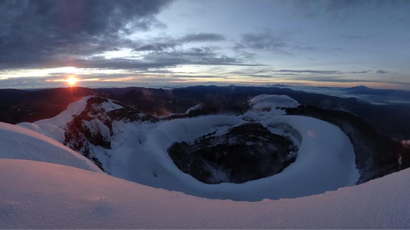
Cotopaxi Volcano . Cotopaxi is a stratovolcano in the Andes Mountains, located about 28 kilometers (17 miles) south of Quito, Ecuador. It is the second highest summit in the country, reaching a height of 5,897 meters (19,347 feet).
Cotopaxi has an almost symmetrical cone that rises from a highland plain of about 3,800 meters (12,500 feet), with a width at its base of about 23 kilometres (14 miles). It has one of the few equatorial glaciers in the world, which starts at the height of 5,000 metres (16,400 feet). The mountain is clearly visible on the skyline from Quito. It is part of the chain of volcanoes around the Pacific plate known as the Pacific Ring of Fire.
Chimborazo Volcano. Chimborazo is a currently inactive stratovolcano located in the Cordillera Occidental range of the Andes. Its last known eruption is believed to have occurred around 550 AD.
With a peak elevation of 6,268 metres (20,564 feet), Chimborazo is the highest mountain in Ecuador. It is the highest peak in close proximity to the equator. While Chimborazo is not the highest mountain by elevation above sea level, its location along the equatorial bulge makes its summit the farthest point on the Earth’s surface from the Earth’s center.
Chimborazo is located in 150 kilometers (93 miles) south-southwest of the capital Quito. It is a neighbor to 5,018 m high Carihuairazo. Chimborazo’s summit rises 2,500 meters above the surrounding highlands (between 3,500 to 4,000 meters) with an 20 km wide base.
Under clear conditions the summit of Chimborazo can be seen from the coastal city Guayaquil, nearly 140 kilometers away. The nearest cities are Riobamba (30 km to the southeast), Ambato (30 km to the northeast) and Guaranda (25 kilometers to the southwest). Chimborazo is surrounded by the Reserva de Produccion Faunistica Chimborazo which forms a protected ecosystem to preserve the habitat for the Andes native camelids of vicuña, llama and alpaca.
Quilotoa Loop. Quilotoa Loop is a water-filled caldera and the most western volcano in the Ecuadorian Andes. The 3 kilometres (2 miles) wide caldera was formed by the collapse of this dacite volcano following a catastrophic VEI-6 eruption about 800 years ago, which produced pyroclastic flows and lahars that reached the Pacific Ocean, and spread an airborne deposit of volcanic ash throughout the northern Andes. The caldera has since accumulated a 250 meter (820 feet) deep crater lake, which has a greenish color as a result of dissolved minerals. Fumaroles are found on the lake floor and hot springs occur on the eastern flank of the volcano.
Quilotoa is a tourist site of growing popularity. The route to the “summit” (the small town of Quilotoa) is generally traveled by hired truck or bus from the town of Zumbahua 17 kilometers to the South. Visitors must pay two US dollars each to look from the lip of the caldera. A number of simple hotels have developed in the immediate area, and offer services such as mules and guides for the five hour hike around the caldera (whose diameter is about 9 kilometers), a half hour hike down (and 1 – 2 hour hike back up the 400 meter vertical ascent), and very basic lodging down in its bowl. Camping is permitted at the bottom of the crater, but there is no drinking water available (except half-liter bottles sold at the hostel), and only a single pit toilet, located in the hostel.
Baños de Agua Santa. The city of Baños has been facing eruption from Tungurahua Volcano for over a decade now. The city is not directly affected and the views are absolutely breath taking. The main issue happened when the volcanic activity from Tungurahua Volcano forced an evacuation from Baños during 1999 – 2000, the small city is one of the top destinations for Ecuadorian tourists. Local and foreign visitors just love it. They come to see the old city buildings such as the church, the city’s famous hot springs, the untouched mountains and scenery. It also has great accessibility to the Amazon rainforest via Puyo just one hour away. In fact, the city sits in the center of the Ecuadorian territory making it very easy for most tourists to get here move freely around the country.
Getting To and Around Baños:
Direct and connected flights to Ecuador are available all year round. During low season cheap flights to Ecuador can be booked for heavily discounted prices. From Quito (the capital) and other Ecuadorian cities, bus connections to Baños are available every day. There are lots of online web portal that specialise in tourist services, information and more. For example the portal www.imagineecuador.com offers interesting information about Baños and a web directory where you can search for hostels, hotels and attractions prior to your arrival.
Bus services depart from all over the countryside. The main services run out of Tungurahua, Quito, Guayaquil, Cuenca, Latacunga, Riobamba and, Puyo. The bus station Quitumbe in Quito is located in walking distance to most of the hotels and hostels.
Car rental is available in the city and is offered by most travel agencies, however due to the nature of the activities planned in Baños, the service is not so popular unless you plan to travel away from the city.
Best Times to Visit. Ecuador due to its geographical location enjoys a spring like climate year round – the four seasons are just a myth here! The weather is constantly giving you four seasons in one day! It is common to have warm rain two times per week for example, but not for over 10 – 20 minutes. Cloudy weather when present doesn´t interfere with tours.
Baños during the weekend tends to be quiet crowded. I suggest you plan your trip during the week p if you prefer the typical peaceful atmosphere that Baños has to offer.
Local Events. The anniversary of Baños is celebrated 15 – 16 December. The fiesta begins the evening before with the famous “verbenas”. Every neighborhood, or barrio in Spanish organizes a party which features local talent who play Andean music and latin rhythms from this region.
Locals drink a sugar cane alcohol called puro and dance on the street. The anniversary day is also celebrated with parades, presentations, street fairs and sports events but mainly the election of Reina de Baños (Miss Baños).
Things to Do in Banos
Plan to visit the church museum and local art galleries. Some local artists have won international awards for their Andean artwork.
The name Baños (pronounced by some people Banios or Banos) came from the hot springs found all around the city. The baths, “baños”, are located just a few blocks away from the city center. Baños water is sometimes yellow colored by the high mineral content, and the temperature varies by the amount of cold water mixed into the bath. I suggest you go and enjoy at least once the thermal springs in town. Preferably, La Virgen hot springs – this is one of the hot spots for locals and tourists alike . Also there are springs located in Santa Clara that feature a sauna and a gym as well. El Salado hot springs are 5 minutes away if you take a local bus or a taxi. Some other hot springs such as, Santa Ana, and Eduardo’s baths are near town. Just ask a friendly local who will assist you with directions once you are in the city.
There is a beautiful waterfall next to La Virgen hot springs – make sure you spend time there, especially for the spectacular photo opportunities.
Another ´must see´ place to visit and is called El Manto de la Novia. You can hire a local tour guide for this kind of trip. Prices are low and the adventure is worth it! A one day tour will ensure you get to see everything.
Spanish schools in Baños are great way to meet new people, make friends and get into the local culture by learning a new language: Espanol.
Activities in Baños :
Whitewater Rafting, Whitewater Kayaking, Canyoning, Rock Climbing, Paragliding, Zip Lining, Bridge Jumping, Mountain Biking, Slacklining, Horse Riding and Hiking.
Baños Tour Operators
The most reputable company in Banos is Imagine Ecuador, they are specialized in Galapagos , Amazon, outdoor adventures and climbing.
Local Markets and Shopping * Local Markets offer fresh fruits, vegetables and more for very low price. Perfect for the backpacker budget! Make sure to wash your fruits before you eat them.
* Visit the famous local handicraft market. Try your hand at bartering but don´t go overboard! Craft stalls and shops offer handiwork made with wood, wool and silver. The jewellery in particular is very popular. Bigger shops accept credit cards, however, in the streets they accept cash only. Banks and ATM’s are all available on the main streets. Banco Pichincha is located on the corner of Thomas Halflants and Ambato Streets, Baños.
* Be sure to sink your teeth into some Melcocha! You can even see this sweet treat being prepared all across town. The locals prepare it by pulling and beating the taffy against a door frame – a sight to be seen and definitely not something you see every day! Traditionally, this taffy is eaten with a big class of morocho, a milk based beverage with corn and no added sugar. Locals who don´t have such a sweet tooth enjoy this snack with morocho.
Spondylus Route
General Information
The provinces of Esmeraldas, Manabí, Guayas, El Oro and Los Rios, make up the Ecuadorian coastline with wonderful beaches and ports and more than 2,000 kilometers. The weather here is an average of 25ºC (76º F) to 30ºC (90º F). From December to May is the rainy season (Winter), when the weather is usually warmer. The dry season is between April and November, cooler and less humid.
ESMERALDAS PROVINCE
Esmeraldas. The largest port in northern Ecuador with 126,000 inhabitants. The name of “Esmeraldas” is due to the green color of its forests, the climate is warm humid with a temperature of 25 degrees with the population of 360,000 inhabitants.
The Cayapas-Mataje ecological reserve, located in the northern Esmeraldas, is extensive and spectacular. The main feature of Cayapas-Mataje is the El Majagual Forest, where the world’s tallest mangroves grow. It is impressive to see their huge roots intertwined in marshland and creeks.
The most exciting time to visit Esmeraldas is during the first five days of August when the city shuts down its usual activities and transforms into one massive party celebrating its Independence.
Tourist Acctractions
Muisne. This small port located on an island offers some basic accommodation and nice restaurants.
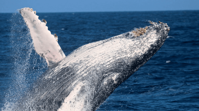
Playa Escondida. The Humpback Whales can be observed from this beach (Between June and September)
Same. This an small and quiet beach resort located some 6 Km southwest from Súa.
Sua. Small fishing village with many pelicans, frigatebirds and other sea birds.
Atacames. This is probably the place in Esmeraldas that attracts the most visitors. It is an all-year-round tourist resort and is located just 30km from the city center. Atacames has a well- developed tourist infrastructure and a wide selection of seaside restaurants and bars, which makes it a great beach destination for relaxing.
San Lorenzo. Known for its maze of canals and is located at the Bahía del Pailón. It is also an strategic place for exciting trips into the virgin rainforests .
MANABI PROVINCE
The capital of Manabi is Portoviejo, this province is well-known for having the most important cultures of Ecuador, such as the pre-Colombian cultures of Valdivia and Machalilla fact, amongst the most attractive places to visit in Manabi is the Isla de la Plata,
Humpback Whale Watching in Manabi, Ecuador is during the months of June – September. The Humpback Whale can be observed throughout the Ecuadorian Coast, specifically along the Province of Manabi’s coastline. This is where the humpbacks migrate from Antarctica towards to the bodies of warm waters. The Humpback Whale prefer this environment in order to reproduce and foster their young.
Tourist Acctractions
ISLA DE LA PLATA. Located within the Machalilla National Park. Here, you can practice scuba diving, sport fishing and snorkeling. Isla de la Plata is also called “The small Galápagos” because of the similar flora and fauna.
In the season of August and September you can do Humpback Whale watching in thePlata Island, this is an amazing experience that shouldn’t be pass up!
Puerto Lopez. Is a small fishing village The beach is enclosed by cliffs to the north and south.
Machalilla National Park. This is one of the most visited coastal national park with over 60,000 ha, including Isla Salango and Isla de la Plata (Islands) and Los Frailes beach.
Ayampe. This beautifull place is a biodiversity heaven and one of the most recommended places to visit.
Puerto Cayo. A fishing village located west of Jipijapa.
Jipijapa. This town is an important agricultural and Panama hat center located south of Manabí.
Montecristi. This old colonial town is one of the main centers of the Panama hat industry.
Manta. Ecuador’s second main port an important local, international tourist resort and commercial center.
Crucita. It is becoming a very popular beach resort, especially for Hang gliding.
San Jacinto y San Clemente. Located south of Bahía de Caráquez. This is a beach famous for its salt production.
Bahía de Caraquez. Is a relaxed and popular tourist destination resort.
GUAYAS PROVINCE
Guayas province is the Capital of Guayaquil Ecuador’s largest city and main sea port . Guayaquil is the most important Industrial and commercial center of the country. Founded in 1535 by Sebastián de Benalcazar and then again in 1537 by Francisco de Orellana.
Tourist Attractions
Playas. Is the closest beach resort to Guayaquil , this is an amazing place to hung out for the weekend.
Santa Elena. This is the oldest archaeological exhibit of the country.
Salinas. Is Ecuador’s best beach resort and the best for whale watching tours.
Ayangue. A small fishing village located some 40 km north of La Libertad.
Valdivia. A small village famous for the 3000 BC Valdivia culture.
Manglaralto. North of La Libertad. A pleasant quiet beach great for surf.
MONTAÑITA. Is one of the most incredible place to visit in the Coast of Ecuador, if you are looking for the best party and surfing in Ecuador then add Montañita to your wish list.
LOS RIOS PROVINCE
Babahoyo with around 80,000 inhabitants it is the capital of the Province of Los Rios. It is mainly a commercial town.
Quevedo. With a large Chinese colony and lots of Chifas.
El Oro Province
El Oro is the Capital of Machala it is an important city and agricultural center. It also hosts an annual international banana fair in September .
Bolivar Seaport. This is an international port located some 7 km from Machala. Puerto Bolivar exports over 2 million tons of bananas every year.
Santa Rosa. An important annual shrimp festival (from August 24th-30th), where there is a contest for the best shrimp ceviche.
Zaruma. Is a small gold mining town located on a hilltop, with a very interesting old architecture reflected on its wooden buildings and balconies.
Piñas. This is a small pleasant wooden colonial town 15 km from Zaruma. Known for its coffee industry and orchid collectors.
Portovelo. Also known for gold mining, located south of Zaruma.
Huaquillas. The most popular border town with Peru. It has grown lately into a small city.
Typical food in the Coast of Ecuador
In the coast, you can enjoy a variety of typical food and drinks, such as: Conchas asadas” (roasted oysters) , the Encocado de Pescado (fish prepared with coconut juice); Tapao (wheat with fish and banana); Arroz con Menestra, Camarón, y patacones (rice with lentils, shrimp and pressed green fried banana); Ceviches made with fish, Empanadas and bolones de verde (balls made of green banana, that usually have some stuffing inside); Cocada (sweet made of coconut, peanut and brown sugar. Among the typical drinks, you can find: Aguardiente de Caña (sugar cane liquor); Coco con Aguardiente (coconut juice with liquor).